Man-made disaster: Look how Chennai built its way to floods
INDIATODAY.IN | New Delhi, December 2, 2015 | 20:31

See how Chennai has changed over the years
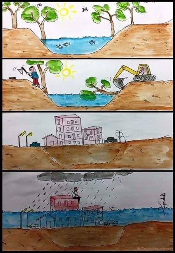
If there are trees, plants and open areas around, rain water will be absorbed by the Earth, but if we continue to build concrete jungles, flooding should not surprise you. Chennai floods is not a natural disaster, it is solely man-made!
Chennai claimed to be Monsoon ready even before it set in. The Corporation of Chennai ensured more than 6,200 metric tonnes of silt from the 1,860 km-long water drain network was removed. But all the apparent efforts by the corporation seems to have been flooded with the city being in a state of disaster. The problem not only lies with the inefficiency of the civic body but also the unplanned and improper development of the city.
Chennai's original terrain consists of many lakes and marshes which now is covered with innumerous buildings. Over 5,550 hectares of wetlands in the IT Corridor of Velachery, Pallikaranai and Old Mahabalipuram Road (OMR) have been developed into commercial real-estate because of which the rain water has nowhere to go and thus, settles instead on the road. There are areas in Chennai which are flooded even during normal Monsoon season.
The capital city of Tamil Nadu is going through inevitable growth and the situation will remain the same. The only way to stop the flooding is to cut on the construction process which has made Chennai populated and which acts as a hindrance to settling down of water. A cautionary plan that goes well with the original geography of the city needs to implemented by the state government when the officially recognized 'disaster zone' is to saved from the doom.
Let us take a look at how different was Chennai in 2000s from the present 'highly developed' (read unplanned) Chennai:
http://indiatoday.intoday.in/story/chennai-floods-man-made-disaster-building-construction/1/537094.html
Making of a disaster:
INDIATODAY.IN | New Delhi, December 2, 2015 | 20:31
See how Chennai has changed over the years
If there are trees, plants and open areas around, rain water will be absorbed by the Earth, but if we continue to build concrete jungles, flooding should not surprise you. Chennai floods is not a natural disaster, it is solely man-made!
Chennai claimed to be Monsoon ready even before it set in. The Corporation of Chennai ensured more than 6,200 metric tonnes of silt from the 1,860 km-long water drain network was removed. But all the apparent efforts by the corporation seems to have been flooded with the city being in a state of disaster. The problem not only lies with the inefficiency of the civic body but also the unplanned and improper development of the city.
Chennai's original terrain consists of many lakes and marshes which now is covered with innumerous buildings. Over 5,550 hectares of wetlands in the IT Corridor of Velachery, Pallikaranai and Old Mahabalipuram Road (OMR) have been developed into commercial real-estate because of which the rain water has nowhere to go and thus, settles instead on the road. There are areas in Chennai which are flooded even during normal Monsoon season.
The capital city of Tamil Nadu is going through inevitable growth and the situation will remain the same. The only way to stop the flooding is to cut on the construction process which has made Chennai populated and which acts as a hindrance to settling down of water. A cautionary plan that goes well with the original geography of the city needs to implemented by the state government when the officially recognized 'disaster zone' is to saved from the doom.
What resulted in the Chennai floods?
- Filling up lowlands without proper planning, little space for stormwater to drain and heavy encroachment of the river banks was one major reason for Chennai floods.
- Illegal constructions, mostly multistorey apartments and huge industries, played the next big part in making way to the floods.
- Over 300 water bodies disappeared due to this.
Let us take a look at how different was Chennai in 2000s from the present 'highly developed' (read unplanned) Chennai:
Let us take a look at how different was Chennai in 2000s from the present 'highly developed' (read unplanned) Chennai:
Let us take a look at how different was Chennai in 2000s from the present 'highly developed' (read unplanned) Chennai:
(Slide the divider to move between years 2000 and 2015.)
Adyar
Chennai International Airport
Anna Nagar
Madippakam
Pallavaram
Porur
Perumbakkam
Porur
Perumbakkam
http://indiatoday.intoday.in/story/chennai-floods-man-made-disaster-building-construction/1/537094.html
Making of a disaster:
Satellite images show how Chennai's new urban jungles caused flooding
Once the water recedes, encroachments by the poor will be targeted and the elite ones tolerated and even encouraged.
Nityanand Jayaraman| Sunday, December 6, 2015 - 09:23

India is a country with a rich tradition of rituals. Even post-mortem discussions about lessons learnt from a disaster are reduced to a mere ritual. Every December since 2004, I write articles about the tsunami and the lessons taught by that giant wave. Then there is the Bhopal disaster season of December, the Fukushima nuclear disaster season in March. But with natural disasters becoming so commonplace, we don't but could observe several other seasons.
These include heat wave season between May-June, Odisha cyclone season after July, the southwest monsoon-flooding season between July and September. We could also observe the northeast monsoon-flooding season between November and December, and the Andhra, Nagapattinam or Cuddalore cyclone season between October and December.
In January, when dry weather returns, the floods will be a distant memory. When rains render people homeless, kind-hearted people jump to aid them, house them and care for them. When the Corporation of Chennai renders them homeless by evicting them to beautify the Cooum, we either sit by and watch, or worse, laud the efforts as a necessary move to clear waterways and water bodies.
We can be sure that, once the water recedes and the resolute survivors of this tragedy begin to rebuild their lives, the Government of Tamil Nadu will use the floods as a justification for the forcible but selective eviction of encroachments. Encroachments by the poor will be targeted, and elite encroachments tolerated and even encouraged.
The word "Encroachment" is often only seen in its legal sense -- on whether the structure has legal sanction or not. Nature does not look at encroachments in this minimalist manner. A perfectly legal building with all the necessary papers can still be an encroachment if it is located in an environmentally sensitive area. The MRTS train line, running through the Buckingham Canal is an encroachment. The Madurai High Court premises located inside a water body is an encroachment. Below is a selection of encroachments in water bodies, or on watercourses. Many of the below places were badly affected during this years floods.
1. Indian Maritime University, Uthandi:

(The area in 2002)
Indian Maritime University is an engineering university that is coming up in a flat sandy area, which is part of a floodplain on the western side of the Buckingham Canal and Kovalam Creek at Uthandi. The area is entirely paved. Where sand has a great capacity to absorb rainwater and reduce run-off, paved surfaces will exacerbate flooding through increased run-off. The college is not yet fully open. But when it does open, and when the next unprecedented rains visit us in the not too distant future, students can thank the management, not Ramanan, for the rain holidays.

(The area in 2015)
2. Chembarambakkam:

(The area in 2002)
This lake has been unfairly blamed for causing people harm this monsoon. Indeed, automakers and IT companies have found fault with "namma chennai" and complained that the flooding shows the city in poor light. This is ironical, since it is these companies and the infrastructure that they have demanded that has hurt so many Chennaiites.
In Chembarambakkam, as in Oragadam, auto manufacturers and their suppliers have populated hydrologically sensitive catchment areas with their factories. The road to a watery hell, they say, is paved. Hyundai Motors operates a factory near Chembarambakkam lake.

(The area in 2015)
3. Oragadam:

(The area in 2006)
Renault Nissan, Daimler Benz and Ford operate auto factories on lands that were once water bodies, paddy lands and forests. All automakers have suspended production at their plants until further notice.

(The area in 2014)
4. Kovalam Creek:

(The area in 2002)
Resort tourism and high-end farmhouses have come up along the creek compromising the ability of the creek to mitigate flooding.

(The area in 2015)
5. Okkiyam Thuraipakkam:

(The area in 2002)
The Okkiyam Maduvu is a narrow chicken's neck watercourse that facilitates tidal exchange in the mighty Pallikaranai marshland. Wise planners would have left a healthy buffer around the Maduvu. But Chennai has permitted IT companies, apartment complexes for IT employees, and the Kannagi Nagar colony to come up close to where floodwaters converge to pour into the Maduvu. These areas were badly affected.

(The area in 2015)
6. Siruseri:

(The area in 2002)
The area where IT industries have come up in SIPCOT, Siruseri, was and still is the converging point for floodwaters from two drainage systems entering the Kovalam creek. SIPCOT is under water and inaccessible.

(The area in 2015)
7. Velachery:

(The area in 2000)
If you look at the Velachery area before the MRTS and the explosion of construction that rode the coat-tails of the IT boom, it is no wonder that Velachery was badly hit in this year's rains.

(The area in 2015)
8. Sholinganallur

(The area in 2002)
Sholinganallur has seen local land-use change drastically in the areas between the Old Mahabalipuram Road (OMR) and the Buckingham Canal. The OMR itself has become a multi-lane raised road that cuts across the drainage path of waters headed to the Buckingham canal.

(The area in 2015)


Once the water recedes, encroachments by the poor will be targeted and the elite ones tolerated and even encouraged.
Nityanand Jayaraman| Sunday, December 6, 2015 - 09:23
India is a country with a rich tradition of rituals. Even post-mortem discussions about lessons learnt from a disaster are reduced to a mere ritual. Every December since 2004, I write articles about the tsunami and the lessons taught by that giant wave. Then there is the Bhopal disaster season of December, the Fukushima nuclear disaster season in March. But with natural disasters becoming so commonplace, we don't but could observe several other seasons.
These include heat wave season between May-June, Odisha cyclone season after July, the southwest monsoon-flooding season between July and September. We could also observe the northeast monsoon-flooding season between November and December, and the Andhra, Nagapattinam or Cuddalore cyclone season between October and December.
In January, when dry weather returns, the floods will be a distant memory. When rains render people homeless, kind-hearted people jump to aid them, house them and care for them. When the Corporation of Chennai renders them homeless by evicting them to beautify the Cooum, we either sit by and watch, or worse, laud the efforts as a necessary move to clear waterways and water bodies.
We can be sure that, once the water recedes and the resolute survivors of this tragedy begin to rebuild their lives, the Government of Tamil Nadu will use the floods as a justification for the forcible but selective eviction of encroachments. Encroachments by the poor will be targeted, and elite encroachments tolerated and even encouraged.
The word "Encroachment" is often only seen in its legal sense -- on whether the structure has legal sanction or not. Nature does not look at encroachments in this minimalist manner. A perfectly legal building with all the necessary papers can still be an encroachment if it is located in an environmentally sensitive area. The MRTS train line, running through the Buckingham Canal is an encroachment. The Madurai High Court premises located inside a water body is an encroachment. Below is a selection of encroachments in water bodies, or on watercourses. Many of the below places were badly affected during this years floods.
1. Indian Maritime University, Uthandi:
(The area in 2002)
Indian Maritime University is an engineering university that is coming up in a flat sandy area, which is part of a floodplain on the western side of the Buckingham Canal and Kovalam Creek at Uthandi. The area is entirely paved. Where sand has a great capacity to absorb rainwater and reduce run-off, paved surfaces will exacerbate flooding through increased run-off. The college is not yet fully open. But when it does open, and when the next unprecedented rains visit us in the not too distant future, students can thank the management, not Ramanan, for the rain holidays.
(The area in 2015)
2. Chembarambakkam:
(The area in 2002)
This lake has been unfairly blamed for causing people harm this monsoon. Indeed, automakers and IT companies have found fault with "namma chennai" and complained that the flooding shows the city in poor light. This is ironical, since it is these companies and the infrastructure that they have demanded that has hurt so many Chennaiites.
In Chembarambakkam, as in Oragadam, auto manufacturers and their suppliers have populated hydrologically sensitive catchment areas with their factories. The road to a watery hell, they say, is paved. Hyundai Motors operates a factory near Chembarambakkam lake.
(The area in 2015)
3. Oragadam:
(The area in 2006)
Renault Nissan, Daimler Benz and Ford operate auto factories on lands that were once water bodies, paddy lands and forests. All automakers have suspended production at their plants until further notice.
(The area in 2014)
4. Kovalam Creek:
(The area in 2002)
Resort tourism and high-end farmhouses have come up along the creek compromising the ability of the creek to mitigate flooding.
(The area in 2015)
5. Okkiyam Thuraipakkam:
(The area in 2002)
The Okkiyam Maduvu is a narrow chicken's neck watercourse that facilitates tidal exchange in the mighty Pallikaranai marshland. Wise planners would have left a healthy buffer around the Maduvu. But Chennai has permitted IT companies, apartment complexes for IT employees, and the Kannagi Nagar colony to come up close to where floodwaters converge to pour into the Maduvu. These areas were badly affected.
(The area in 2015)
6. Siruseri:
(The area in 2002)
The area where IT industries have come up in SIPCOT, Siruseri, was and still is the converging point for floodwaters from two drainage systems entering the Kovalam creek. SIPCOT is under water and inaccessible.
(The area in 2015)
7. Velachery:
(The area in 2000)
If you look at the Velachery area before the MRTS and the explosion of construction that rode the coat-tails of the IT boom, it is no wonder that Velachery was badly hit in this year's rains.
(The area in 2015)
8. Sholinganallur
(The area in 2002)
Sholinganallur has seen local land-use change drastically in the areas between the Old Mahabalipuram Road (OMR) and the Buckingham Canal. The OMR itself has become a multi-lane raised road that cuts across the drainage path of waters headed to the Buckingham canal.
(The area in 2015)
Which are the areas that will see severe water logging when water from water bodies like Adyar River, Cooum or Chembarambakkam Lake overflows?
Which parts of Chennai have the potential of flooding and need to be avoided?
Which are the relatively safe areas that you could move to when rain starts pounding?
These maps have been put together by Sashikumar N of HydroInfotech Solutions, Bengaluru.
They have been designed from data available in the public domain from remote sensing satellites of NASA.
Are they the most scientific and accurate? Well, they might not be, because the data for these maps have been collated from what NASA has made available completely in the public domain. But do they give a fairly comprehensive picture of what Chennai’s flood potential looks like – YES.
How to decipher these maps?
Map 1: Charts out the elevation levels of various areas of Chennai.
Pale blue: The lowest areas when compared to sea level. They have the highest potential for flooding,
Purple: Slightly higher elevation than the blue ones, which means they are still under a risk of flooding.
Green: Higher than the purple or the blue patches, which lowers the potential for flooding.
It is not rocket science to know that water flows from an elevated area to a low lying area. Which means all rain from the green areas is flowing to the blue or purple areas.
When the rivers like Adayar and Cooum or lakes like Chembarambakkam or Porur overflow, the blue and purple areas are worst hit.
These are the areas that need to be prioritized for evacuation and preparation. And evidently, in the current catastrophe, most of these zones have been worst hit.
Map 2: Shows streams in Chennai that are likely to overflow if blocked with construction of buildings.
Look for the thin blue lines all across the maps. The lines might look thin but try obstructing the water flow with a building, and you will see the disaster these streams can cause.
Map 3: The extent of rainfall recorded in various districts of Tamil Nadu that shows the extent of rainfall from Nov 22 to Dec 1.
This throws open a little-known fact - Pondicherry, Maduranthakam and other districts received more rainfall than Chennai.
Dark red: Highest rainfall
Orange: Heavy to very heavy rainfall
Yellow: Heavy rainfall
The scale in the map will guide you to the amount of rain recorded in each district.
- See more at: http://www.thenewsminute.com/article/deciphering-chennai-floods-three-maps-and-overview-36559#sthash.OWSNkm2l.dpuf
This comment has been removed by the author.
ReplyDeleteNice blog! Thanks for sharing blogs with us. keep blogging.
ReplyDeleteRegards,
Health Care for the Poor | Shanthi Bhavan | All The Children | Top 10 NGOs in India